CONFERENCE WORKSHOP DATE - 1st of December 2017
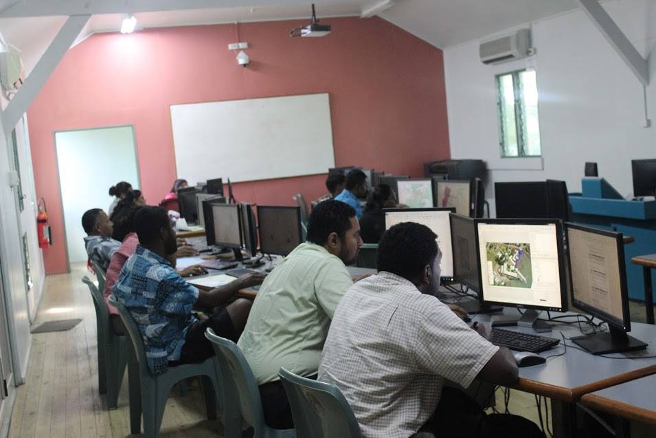
Workshops are available to all conference participants. It always proves to be a popular and important activity, that takes places a day after the conference, concurrently in different locations. These locations are usually at the SPC, Geoscience Division Campus in Nabua and at the University of the South Pacific , Laucala Campus.
Various GIS and Remote Sensing experts from the region and from the international arena will be conducting the workshop, with topics and hands on activities useful to the development of the Pacific region. This is an exciting opportunity to learn and progress your skills on the latest GIS and RS evolution.
Register with Miss Naomi Jackson. email: This email address is being protected from spambots. You need JavaScript enabled to view it.
You can view the list and details of workshops below.
_________________________________________________________________________________________
2017 WORKSHOP DETAILS
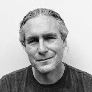
Workshop 1. Lidar Application and Point Cloud Mapping by Dr Martin Isenburg
Venue: USP Lower Campus Geospatial labs
Date & Time: Friday, 1 December, 8:30AM - 1PM
Biography:
Dr. Isenburg received his MSc in 1999 from the University of British Columbia in Vancouver, Canada and his PhD in 2004 from the University of North Carolina at Chapel Hill, USA – both in Computer Science. Currently, he is an independent scientist, lecturer, and research consultant. Dr. Isenburg has created a popular suite of LiDAR processing software modules called LAStools that is the flagship product of rapidlasso GmbH, the company he founded in 2012. The LAStools software suite has deep market penetration and is heavily used in industry, government agencies, research labs, and educational institutions alike. This efficient LiDAR processing software combines robust algorithms with efficient I/O and clever memory management to achieve high throughput for data sets containing billions of points. See http://rapidlasso.com for more information.
Title: Processing LiDAR and Photogrammetry Point Clouds with LAStools
Abstract: Dr. Isenburg will start with a short intuitive introduction to LiDAR processing using examples of different projects such as flood mapping in the Philippines, archaeological finds in Polish forests, mapping biomass in Thailand, elevation errors of up to 25 meters in official government maps derived with photogrammetry that are uncovered by vegetation-penetrating lasers in the Canary Islands (Spain).
This is followed by a hands-on morning session during which attendees will perform the core steps of a LiDAR processing workflow on their own Windows laptops using the software and data provided. We will touch upon parts of (1) LiDAR quality checking such as pulse density, coverage, and flightline alignment, (2) LiDAR preparation (compressing, tiling, denoising, classifying), and (3) LiDAR derivative creation (DTM and DSM rasters, contours, CHM or DSM rasters). In the afternoon we switch focus from LiDAR to photogrammetry point clouds that - at least for smaller areas - are fairly easy and cheap to create with low-cost drones and dense-matching software. We learn about the common difficulties of processing these point clouds into a Digital Terrain Model (DTM) in the presence of vegetation or excessive low noise.
Requirements: Any computer or laptop with Windows operating system and 10 GB (or more) hard drive space. Enough power outlets.
________________________________________________________________________________________________________________________
Workshop 2. QGIS Customization by Jonah Sullivan ( Geoscience Australia) & Olivier Dalang (SPC)

Venue: USP Lower Campus Geospatial labs
Date & Time: Friday, 1st December, 9AM to 12PM
Title: QGIS Customisation using Python
Abstract: A QGIS Python Plugin development walkthrough.
Requirements: Please ensure you have the latest QGIS installed from http://qgis.org/downloads/QGIS-OSGeo4W-2.18.9-1-Setup-x86_64.exe and also install the "Plugin Builder" plugin.
_____________________________________________________________________________________
Workshop 3. High resolution satellite imagery application and exploitation techniquesby Andrew Steele

Due to unforeseen cirumstances, Andrew Steele has been unable to attend the conferece. Therefore this workshop has been cancelled. We apologise for any inconvenience caused.
______________________________________________________________________________________
Workshop 4: Have a drone, now what? An introduction on how to process Drone aerial imagery with PIX4D Mapper Pro

Venue: USP Lower Campus Geospatial labs
Date & Time: Friday, 1 December, 2PM to 5PM,
Presenter: Miss Suluweti Nairaitoga, GIS Technician - Drone Services Fiji
Workshop content
- Demonstration of a precision mapping drone and base station for GCPs
- Preparing a data set for PIX4D (Geo-tagging)
- PIX4D initial processing
- How to insert GCP’s
- Point Cloud & 3D Mesh processing
- Orthomosaic, DSM, DTM, contour processing
- Cloud processing and sharing results and reports
_________________________________________________________________________________________________________________________________
Workshop 5: The Geodesy and Crustal Deformation Training Workshop BY Christopher Pearson
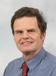
Venue : SPC, GEM Division, Big Water Conference Room
Workshop Shedule:
The workshop is divided into two sessions.
Morning Session - Geodetic surveying and Crustal Deformation models
Afternoon Session - Least square adjustments with LINZ's Survey net Adjustment package"
|
9 to 9:45 |
Network design |
|
9:45 to 10:20 |
GNSS processing |
|
10:20 to 10:30 |
Tea break |
|
10:30 to 11:15 |
Introduction to deformation models |
|
11:15 to 12 |
deformation models for the South Pacific region |
|
12 to 1 |
Lunch |
|
1 to 1:45 |
introduction to Least Squares |
|
1:45 to 2:30 |
introduction to SNAP |
|
2:30 to 3:15 |
First exercise |
|
3:15to 3:30 |
afternoon tea |
|
3:30-4:30 |
2nd exercise |
